
THE CASA GRANDE PHOTOGRAMMETRIC TEST RANGE
ABSTRACT
The Casa Grande Photogrammetric Test Range was established in the mid-sixties to test the dynamic performance of aerial cartographic cameras. A discussion of-the test range design and the field surveys required to establish it is presented. In addition, the photogrammetric procedures normally used to test aerial mapping cameras using the range are· presented.
Arizona has many firsts to its credit, a number of which are nationally and internationally-known, even to those who have never been here. Think of Arizona and you probably think of the Grand Canyon, the London Bridge, copper and sunshine, and even retirement. Due largely to the sunshine, the Casa Grande Test Range is located to the southeast of Phoenix near the town of Casa Grande. The number of cloud-free, sunny days is an important consideration to aerial photography acquisition and for testing the systems used to acquire it.
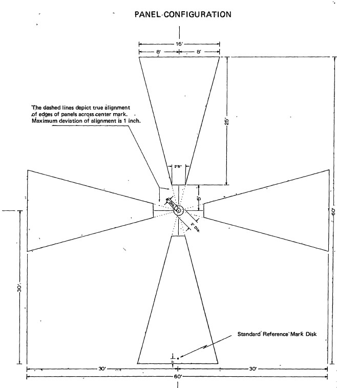
Millions of people arrive at or depart from Phoenix each year by air, rail, bus, and auto. No doubt, a number of them, when flying over or passing by Casa Grande, have observed large concrete crosses (similar to Maltese crosses in design) constructed flat on the ground at regular intervals, and have wondered just what they were and why they were there. These crosses are concrete panels which have been geodetically controlled and are essential parts of the Casa Grande Photogrammetric Test Range. As constructed, it was probably the most, precise aerial camera test range in the free-world. Presented herein is a discussion of the test range design, the field surveys required to establish it, their attendant accuracies, and related items of interest.
The Casa Grande Test Range is not the only range employed by the U.S. civil and military mapping establishments. The National Geodetic Survey (NGS), formerly the U.S. Coast and Geodetic Survey (USC&GS), built the McClure Range in Ohio and continues to maintain it.
The Defense Mapping Agency Topographic Center (DMATC), formerly the Army Map Service (AMS), established the Arizona Test Area encompassing Phoenix in 1947 and enlarged it in 1960. Other ranges with photogrammetric targets exist throughout the country, as well as laboratories where aerial cameras are statically calibrated.
In 1965, an expanded test range was needed for dynamic camera performance and evaluation purposes plus other photogrammetric related research, development, test and evaluation needs. On this range, greatly improved survey accuracies were required in positioning test range panels because of the increased accuracy capabilities of aerial cameras, photogrammetric instrumentation, and techniques. The McClure Range was accurate but too small and the Arizona Test Area. was large enough but not sufficiently accurate.
Therefore, office-type reconnaissance began for the selection of a new area. Due consideration was given to factors such as overflight restrictions, general terrain and vegetation, weather, and expected land lease costs, etc. The Casa Grande area was selected,
in spite of the land subsidence, because of all the other favorable characteristics. Yet, it must be said that we were not aware of the magnitude of the subsidence at the time.
Read the rest of the document that I uploaded to the Internet Archive: https://archive.org/download/the-casagrande-photogrammetric-test-range/THE%20CASAGRANDE-PHOTOGRAMMETRIC%20TEST%20RANGE.pdf
