Yeah, I waste time on Facebook – this I cannot deny. I try to limit the time I spend there, but the diminishing rate of return (relevant information vs time spent) has been steadily decreasing over the last few years. (Note to my readers viewing this on FB: this is not an anti-FB rant)
In the last few months, I’ve had some attention-getting advertisements show up… and yes, I have clicked on them (Bad, I know). Today’s adventure in time wasting brought me to a set of cards about logical fallacies, and its “sister” deck on cognitive bias. I will throw the link out there, just if you’re interested. Otherwise, ignore the shout-out and read on.
(No, I’m not an associate making money on this. I just think its a good teaching tool)
I clicked on the link to the store, and liked what the products had to offer. I’ve know about the biases and fallacies for a while now – often folks would engage in attacks on social media, and others would call them out with a specific counter argument. The most tantalizing “flame wars” would show the counter argument and an explanation in general terms (as not to further throw gasoline on the figurative fire), to the original arguments’ holes.
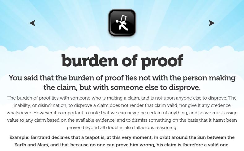
The decks of cards and their prompts were intriguing, and I thought I might use a few as brain-teasers to further my writing on the Arizona Concrete Crosses. I will throw out a screenshot of one of the cards – Burden of Proof – as an example. I won’t repeat this, however, because it may tick off the company trying to make a few dollars.
Ah, so I cannot disprove that the Arizona Concrete Crosses were used for the CORONA spy satellite program. I knew this from the start. I know that the utility of such a large infrastructure project would be tantalizing for project planners to want to use. Heck, I remember having to plan for situations when it was encouraged to use existing infrastructure, computer code, or checklists… even though they did not fit the requirements I specified.
When I was on alert, would I use a launch checklist to order my lunch? Probably not. I would use a lunch checklist, if one existed… but alas one such checklist does not. And no, missile geeks…MAF Activities is not purely a lunch checklist, . Couldn’t help presenting the pun, though.
Back to the chunks of concrete in Arizona…
So, I realized that I cannot to prove to you – my audience – beyond a reasonable doubt of my strong suspicion that the 273 crosses were not used to “help” calibrate the CORONA spysats on their primary mission of photographic intelligence, because I will fail to provide a reasonable Burden of Proof against the argument. There will be no document within the CIA, NRO, or NPIC archives that will plainly say “We’re not using the Casa Grande Test Range to calibrate CORONA.” (Though if a memo like that existed, I would post it ALL OVER the internet!)
No, the best I can do is give you “food-for-thought” about the existence of the crosses, their technical dimensions, and any information I’ve found with their publicly stated purpose… but I shall provide evidence to my hypothesis that the COntrolled Range Network (CORN) was the true calibration network for the National Reconnaissance Program, to include the CORONA spysats.
We shall go through the evidence together, along with mention of bias and fallacies that many Internet sources have perpetuated, with the ultimate error of calling the Casa Grande Test Range the “CORONA Calibration” test range. (Yes, the strikethrough is intentional, for obvious reasons)

Today’s tidbit is from Mission 4014, a KH-7 GAMBIT satellite that was launched on December 4, 1964 (Zulu time/date). In case you’re wondering why I keep using GAMBIT reports with these blog posts, there are two reasons:
- Many of these are newly released (e.g. have NOT been seen outside classified spaces)
- The CORN descriptions within are quite intriguing (as seen in the above snippet)
- These files are OCR’d for easy searching… for the NRO’s benefit, not mine.
- The CORONA files are not OCR’d. While I’ve read all of them, I haven’t pulled out all of the CORN references yet…
But, the most important reason I use these early KH-7 GAMBIT reports as evidence:
- The bronze survey markers in Arizona state “1966” as the year of construction (or incorporation into the Army Mapping Service geodetic survey database).
- This report shows that in late 1964, KH-7 GAMBIT satellites were frequently pulling in images of around two feet (24-inches, or 0.6096-m for our metric-system inclined readers).
Which leads to Today’s Question:
“Why build an instrument/network that provides a less precise measurement nearly two years later?”
